This is a guest blog from our friends at ESRI.
ESRI is the global market leader in Geographic Information System (GIS) – a computer system for capturing, storing, checking, and displaying data related to positions on Earth’s surface. GIS presents many different kinds of data on one map, which enables people to more easily see, analyze, and understand patterns and relationships and pioneer problem solving through GIS. More than 75% of the Fortune 500 companies deploy ESRI software to meet their business goals.
ESRI’s ArcGIS is the world’s most powerful mapping and spatial analytics software. ArcGIS offers a unique set of capabilities for applying location-based analysis to your business practices, gain greater insights using contextual tools to analyze and visualize your data and finally share these insights and collaborate with others via apps, maps, and reports. Specifically, ArcGIS allows the users to perform Spatial Analytics, Mapping and Visualization, 3D GIS, Real time GIS and Imagery and Remote Sensing. All of these are enabled via the data that ArcGIS allows users to access, use and store.
In a real development environment our customers leverage ArcGIS to read and write geospatial data to a plethora of distributed data stores, such as Amazon S3, HDFS, or OpenStack Swift, and some of these data stores are not natively supported by the ArcGIS platform. Depending on the data store, they may also have to use a different API (mostly Python based) to read and write geospatial information, and ArcPy extends the ArcGIS platform to handle these situations. Nevertheless, accessing and storing data in unsupported data stores requires developers to constantly change the program to accommodate different data stores, which hinders development, and ultimately, impedes the customer’s ability to derive insights from the data.
Enter Alluxio – a memory speed distributed system that virtualizes across disparate storage systems and provides a unified global namespace enabling new workflows across any data in any storage. Thus, at the application level, the code to access the data is invariant. Alluxio can work with any storage, such S3, HDFS or SWIFT. Finally, the advent of a REST endpoint in Alluxio eases the integration with ArcGIS to write, read and visualize Geospatial data.
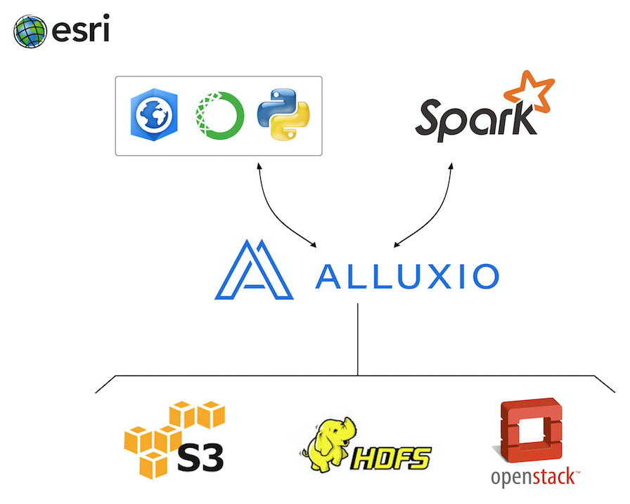
With Alluxio in the data architecture, accessing data from data stores not natively supported by ArcGIS becomes a breeze, the application does not need to make any changes, and just via mounting these backend stores into Alluxio, the application is able to access the data from these stores. This greatly reduces the development time, as code changes are not needed. Additionally, Alluxio’s memory-centric architecture enables memory speed data access, thereby, greatly improving overall performance resulting in faster time to insights.